|
|
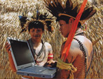
O que poderia ser um critico desenvolvimento na ajuda de monitoramento do desflorestamento dos países tropicais, o Google revelou uma parceria com cientistas usando uma tecnologia remota de sensor para rapidamente analisar e mapear as coberturas florestais em uma resolução extremamente alta. O esforço pode ajudar os países a detectar o desflorestamento logo em seguida a seu acontecimento tornando mais fácil prevenir o desmatamento que ocorre depois.
O desflorestamento e a degradação da floresta é uma grande fonte de emissões de gases de efeito estufa, maior do que todas as emissões advindas dos carros, caminhões, aviões, trens e navios do mundo todos juntos. E também é uma ameaça á biodiversidade, ás culturas indígenas e aos serviços do ecossistema como as provisões de cachoeiras e controle de enchentes. Portanto, um novo mecanismo proposto, que alega diminuir o desflorestamento através da compensação dos países e proprietários para proteger as florestas ganhou grande apoio nas conversações climáticas em Copenhagen. Mas para se qualificar para os pagamentos sob as Emissões Reduzidas do Desflorestamento e Degradação (REDD), os países devem ser capazes de quantificar as reduções do desflorestamento em confronto com sua linha de base histórica — algo dificil para a maioria dos países (nem mesmo países ricos como a Austrália e o Canadá fornecem dados precisos sobre suas florestas). Portanto uma ferramenta que capacita os países a mensurar o desflorestamento passado e rastrear a perda e perturbação florestal logo após sua ocorrência seria de grande valia para os esforços de combate á mudança climática, reduzindo as emissões de gases de efeito estufa advindas do desflorestamento.
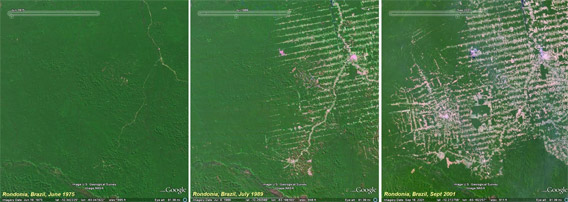
Desflorestamento em Rondônia, Brasil, de 1975 á 2001. Cortesia de imagem da Landsat USGS.
Duas instituições desenvolveram tecnologias que vem tornando essa ferramenta uma realidade: O Instituto Carnegie de Sistema CLASlite de Ciencia (conduzido por Greg Asner), que usa imagem de satélites e laser implantado a partir de aviões (airborne Light Detection and Ranging – LiDAR) para construir mapas de alta resolução e em 3-D das florestas que podem mensurar as atividades madeireiras e outras causas do desflorestamento; e Sistema de Alerta de Desflorestamento Imazon (SAD) (conduzido por Carlos Souza), que usa imagem de satélite para rapidamente detectar e relatar o desflorestamento. Agora, através de um projeto de protótipo, o Google traz o poder dessas tecnologias online, aproveitando sua enorme nuvem de computação.
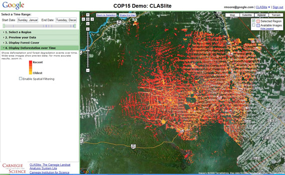
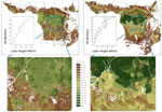
CLASlite online: Esta imagem mostra o desflorestamento e degradação em Rondônia, Brasil de 1986-2008, com o vermelho indicando atividade recente.
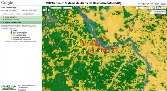
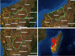
SAD online: Os pontos em vermelho indicam o desflorestamento ocorrido dentro dos últimos 30 dias. O resultado da implantação do SAD em uma região de recente desflorestamento em Mato Grosso, Brasil.
“Com esta tecnologia é possivel para os cientistas analisarem as informações de imagem crua do satellite e extrair significantes informações sobre as florestas do mundo, tais como as locações e mensurações do desflorestamento ou mesmo da regeneração de uma floresta,” escreveu Rebecca Moore e Amy Luers em uma blog post anunciando a parceria.
“Através do fornecimento de grande potencia computacional e fácil acesso á dados masssivos, esta nova tecnologia irá dramaticamente diminuir o custom e a compexidade para as nações tropicais de monitorar suas florestas usando o CLASlite e outros programas de análises florestais,” acrescentou Luers.
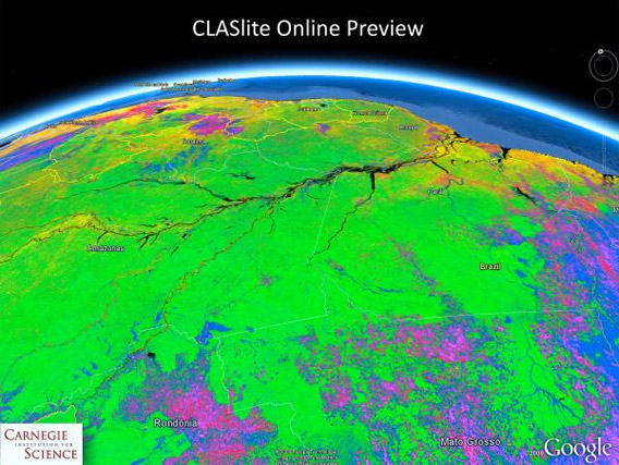
Esta imagem CLASlite da Bacia Amazônica mostra regiões desflorestadas em rosa e azul, e regiões intactas em verde.
A tecnologia está até agora apenas disponível para a Amazônia e a região dos Andes na América do Sul, mas ela pode algum dia se expandir para a Bacia do Congo, outras partes da América Latina e para o Sudeste da Ásia. Eventualmente o sistema poderia ser realmente global com monitoramento quase em tempo real da cobertura florestal (como está atualmente disponível com fire-tracking).
Para mais informações sobre como o sensor remoto pode ajudar a salvar florestas e a vida selvagem, por favor veja Como os satélites são usados na conservação.
Links Relacionados
– Seeing the forest through the cloud (Google Blog)
– CLASlite
– Imazon
Artigos Relacionados
Ethnographic maps built using cutting-edge technology may help Amazon tribes win forest carbon payments
(11/29/2009) A new handbook lays out the methodology for cultural mapping, providing indigenous groups with a powerful tool for defending their land and culture, while enabling them to benefit from some 21st century advancements. Cultural mapping may also facilitate indigenous efforts to win recognition and compensation under a proposed scheme to mitigate climate change through forest conservation. The scheme—known as REDD for reducing emissions from deforestation and degradation—will be a central topic of discussion at next month’s climate talks in Copenhagen, but concerns remain that it could fail to deliver benefits to forest dwellers.
How satellites are used in conservation

(04/13/2009) In October 2008 scientists with the Royal Botanical Garden at Kew discovered a host of previously unknown species in a remote highland forest in Mozambique. The find was no accident: three years earlier, conservationist Julian Bayliss identified the site—Mount Mabu—using Google Earth, a tool that’s rapidly becoming a critical part of conservation efforts around the world. As the discovery in Mozambique suggests, remote sensing is being used for a bewildering array of applications, from monitoring sea ice to detecting deforestation to tracking wildlife. The number of uses grows as the technology matures and becomes more widely available. Google Earth may represent a critical point, bringing the power of remote sensing to the masses and allowing anyone with an Internet connection to attach data to a geographic representation of Earth.
Development of Google Earth a watershed moment for the environment
(03/31/2009) Satellites have long been used to detect and monitor environmental change, but capabilities have vastly improved since the early 1970s when Landsat images were first revealed to the public. Today Google Earth has democratized the availability of satellite imagery, putting high resolution images of the planet within reach of anyone with access to the Internet. In the process, Google Earth has emerged as potent tool for conservation, allowing scientists, activists, and even the general public to create compelling presentations that reach and engage the masses. One of the more prolific developers of Google Earth conservation applications is David Tryse. Neither a scientist nor a formal conservationist, Tryse’s concern for the welfare of the planet led him develop a KML for the Zoological Society of London’s EDGE of Existence program, an initiative to promote awareness of and generating conservation funding for 100 of the world’s rarest species. The KML allows people to surf the planet to see photos of endangered species, information about their habitat, and the threats they face. Tryse has since developed a deforestation tracking application, a KML that highlights hydroelectric threats to Borneo’s rivers, and oil spills and is working on a new tool that will make it even easier for people to create visualizations on Google Earth. Tryse believes the development of Google Earth is a watershed moment for conservation and the environmental movement.
Satellites and Google Earth Prove Potent Conservation Tool
(03/29/2009) Armed with vivid images from space and remote sensing data, scientists, environmentalists, and armchair conservationists are now tracking threats to the planet and making the information available to anyone with an Internet connection.
(03/29/2009) Given that deforestation accounts for nearly one fifth of anthropogenic greenhouse gas emissions, reducing forest clearing and degradation is increasingly seen as an critical component to any framework addressing climate change. By some estimates, a mechanism that compensates countries for reducing emissions from deforestation and forest degradation (REDD) could funnel billions of dollars per year towards forest conservation. However the effectiveness of such a mechanism will hinge on the quality of data. Effective mapping and monitoring of forest carbon stores is absolutely key to any mechanism that compensates countries for reducing emissions from deforestation and forest degradation.
Rainforest canopy-penetrating technology gets boost for forest carbon monitoring
(12/04/2008) A tool for monitoring tropical deforestation has gotten a boost from the one of the world’s largest supporters of Amazon conservation. The Gordon and Betty Moore Foundation has awarded the Carnegie Institution’s Department of Global Ecology with a $1.6-million grant to expand and improve its tropical forest monitoring tool known as the Carnegie Landsat Analysis System Lite (CLASLite).
Fire monitoring by satellite becomes key conservation tool
(03/26/2008) Remote sensing is increasingly used as a tool for conservation management. Beyond traditional satellite imagery popularized by Google Earth, new sensing applications are allowing researchers located anywhere in the world to track fires, illegal logging and mining, and deforestation in some of Earth’s most isolated regions using a computer or handheld device. The Fire Alert System is one example of an application that is harnessing the power of satellites to deliver key data to conservation managers. Developed by Madagascar’s ministry of Environment, the International Resources Group, conservation International using data from the University of Maryland and NASA, the Fire Alert System enables near real-time monitoring of fires anywhere on the island of Madagascar, a hotspot of biological diversity. The system, which sends subscribers regular email alerts on newly-detected burning, will eventually be expanded to include all the world’s protected areas, allowing managers to detect not only fires but potentially related activities like road building, logging, and even hunting.
Complete map of world forests to help REDD carbon trading initiative
(02/27/2008) Policymakers, conservationists and scientists have high hopes that REDD, a mechanism for compensating countries for reducing emissions from deforestation and forest degradation, will spur a massive flow of funds to tropical countries, helping preserve rainforests and delivering economic benefits to impoverished rural communities. To date, one of the biggest hurdles for the initiative has been establishing a baseline for deforestation rates — in order to compensate countries for “avoided deforestation” it first must be known how much forest the country has been losing on a historical basis. Until now, with some notable exceptions, this data was based largely on spotty satellite assessment and surveys of national forestry departments by the U.N. Food and Agricultural Organization.
New satellite system will penetrate clouds to track deforestation
(12/05/2007) Satellite monitoring will play a critical role in any agreement that compensates tropical countries for preserving their forests, such as “Reduced Emissions from Deforestation and Degradation” (REDD) mechanisms currently under discussion at UN climate talks in Bali. Released Tuesday, a new study, “New Eyes in the Sky: Cloud-Free Tropical Forest Monitoring for REDD with the Japanese Advanced Land Observation Satellite (ALOS)”, details significant advancements in the field of remote sensing of forests.
SHARE THIS ARTICLE:

|
function fbs_click() 
|
|||||||||